View in other NatureServe Network Field Guides
NatureServe
Montana
Utah
Wyoming
Idaho
Wisconsin
British Columbia
South Carolina
Yukon
California
New York
Chicken-sage - Sphaeromeria argentea
Other Names:
Tanacetum nuttallii, Artemisia macarthurii, Artemisia nuttallii
State Rank Reason (see State Rank above)
DRAFT: Requesting feedback on the 2026 revised rank, factors, and State Rank Reason outlined below and in the Conservation Status Rank Report.
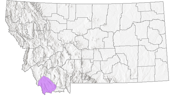
Sphaeromeria argentea is a regional endemic of southwest Montana, adjacent Idaho and extending into southwest Wyoming and adjacent Colorado and parts of Nevada. In Montana, it is restricted to parts of Beaverhead County. Populations appear to be fairly robust and likely number over 10,000 plants. Trends are generally unknown but are believed to be relativey stable at least recently. Known threats appear to be limited to non-native species such as Malcolmia africana and Bromus tectorum invading some of the habitat and livestock grazing at some locations. However, these are likely having only a negligible to minor impact at this time.
Monitoring at a subset of populations is needed to be able to determine if populations are stable and whether grazing or non-native species are having any negative impacts.
General Description
Chicken-sage is a mat-forming perennial herb or sub-shrub with multiple flowering shoots that are 5-20 cm high and many shorter, sterile shoots. The alternate leaves are up to 15 mm long and are narrowly fan-shaped and usually 3-lobed at their tip. They are aromatic and densely covered with appressed, gray hair. Several short-stalked, globose flower heads are borne at the stem tips. Each head has numerous disk flowers and 2-3 series of overlapping, membranous-margined involucral bracts that are 3-4 mm high. There are no ray flowers, and the achenes lack a pappus.
Phenology
Flowering occurs in June and early July.
Diagnostic Characteristics
Chicken sage resembles a small, low-growing sagebrush plant (Artemisia spp.) but has fewer heads per stem. The flower heads are larger and tightly clustered, and the basal leaves are lobed nearly to the base. Recent research supports the placement of Sphaeromeria in Artemisia (Garcia et.al. 2011).
Species Range
Montana Range
Range Descriptions
 Native
Range Comments
Regional endemic known from Point of Rocks spring in Nevada; southwestern Beaverhead County in Montana, Idaho, Wyoming, Colorado.
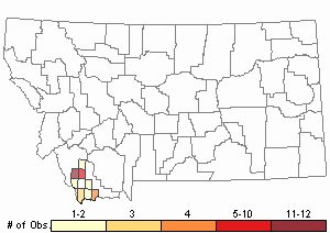
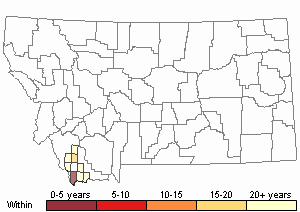
Observations in Montana Natural Heritage Program Database
Number of Observations: 36
(Click on the following maps and charts to see full sized version)
Map Help and Descriptions
Relative Density
Recency

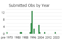
 (Observations spanning multiple months or years are excluded from time charts)
Habitat
Chicken-sage generally grows on shallow limestone-derived soil of sagebrush steppe in the valley and foothill zones. Associated vegetation is quite variable, but all habitats are arid, alkaline and have low vegetation competition.
In the Grasshopper drainage of Beaverhead County, it occurs in two distinct habitats: 1) localized sandy clay pockets of sagebrush steppe dominated by Artemisia arbuscula/Agropyron spicatum, and 2) limestone outcrop ridgetops and slopes covered by dry bunchgrass communities of Agropyron spicatum and cushion plants, at the most sparsely-vegetated local extreme (Heidel and Vanderhorst 1996). In the Rocky Hills and near Bannack, chicken sage grows in openings of a limber pine (Pinus flexilis) and mountain mahogany (Cercocarpus ledifolius) community. Subdominant grasses include Elymus spicatus and Koeleria macrantha. Associated forbs include Erigeron compositus, Erigeron tweedyi, Haplopappus acaulis, Ivesia gordonii, Penstemon aridus and Penstemon eriantherus, all of which are characteristic of limestone outcrops.
In the Sage Creek drainage, this species has been found in heavy soil of eroding slopes at about 6300 feet elevation; common associates include Haplopappus acaulis and Erigeron tweedyi (Lesica and Vanderhorst 1995). It also occurs in this area on dry, rocky bunchgrass slopes not confined to limestone parent material; common associates include Ceratoides lanatus, Selaginella densa, Antennaria microphylla, Astragalus miser, Haplopappus acaulis, Eriogonum mancum, and Erigeron caespitosus. In the drainage of upper Big Sheep Creek, the habitat is an unusual alkaline bottomland community dominated by low sagebrush (Artemisia arbuscula) and greasewood (Sarcobatus vermiculatus).
National Vegetation Classification System Groups Associated with this Species
Forest and Woodland
Low Elevation - Xeric Forest and Woodland
Montane - Subalpine Forest and Woodland
Shrubland
Foothills - Montane Shrubland
Sagebrush Shrubland
Grassland
Lowland - Prairie Grassland
Ecology
Chicken sage is a long-lived perennial. Populations are generally sparse but often widespread. It occurs in many different common habitats but occupies only a small proportion of the apparently available habitat. Chicken sage is aromatic like closely related species of Artemisia and Tanacetum.
Management
The species is an aromatic sub-shrub that grows low to the ground and is likely unpalatable or not affected much by livestock grazing (Vanderhorst and Lesica 1994). Where it grows on steep, rocky slopes, it is not very vulnerable to mechanical disturbance, such as trampling by cattle. However, bottomland habitats are more vulnerable. Grazing, mining and other activities may promote the spread of exotic species such as Bromus tectorum, Centaurea maculosa and Melilotus spp. The species is widespread in southern Beaverhead County, although never abundant. Some populations occur in historic mining districts and could be threatened by future mining activities. However, many of the known populations face no anthropogenic threats.
Stewardship Responsibility
Threats or Limiting Factors
STATE THREAT SCORE REASON
Threat impact not assigned because threats are not known (MTNHP Threat Assessment 2021).
References
- Literature Cited AboveLegend:
 View Online Publication
- Lesica, P., M.T. Lavin, and P.F. Stickney. 2012. Manual of Montana Vascular Plants. Fort Worth, TX: BRIT Press. viii + 771 p.
 MTNHP Threat Assessment. 2021. State Threat Score Assignment and Assessment of Reported Threats from 2006 to 2021 for State-listed Vascular Plants. Botany Program, Montana Natural Heritage Program, Helena, Montana.
- Additional ReferencesLegend: View Online Publication
Do you know of a citation we're missing?- Garcia, Sònia, Teresa Garnatje, E. Durant McArthur, Jaume Pellicer, Stewart C. Sanderson, and Joan Vallès. 2011. Taxonomic and Nomenclatural Rearrangements in Artemisia Subgen. Tridentatae, Including a Redefinition of Sphaeromeria (Asteraceae, Anthemideae). Western North American Naturalist. 71 (2): 158-163.
- Heidel, B.L. and J. Vanderhorst. 1996. Sensitive plant species surveys in the Butte District, Beaverhead and Madison Counties. Unpublished report to the Bureau of Land Management. Montana Natural Heritage Program, Helena, Montana.
- Lesica, P. and J. Vanderhorst. 1995. Sensitive plant survey of the Sage Creek area, Beaverhead County, Montana, Dillon Resource Area, Bureau of Land Management. Unpublished report to the Bureau of Land Management. Montana Natural Heritage Program. 36 pp. plus appendices.
- Lesica, P., M.T. Lavin, and P.F. Stickney. 2022. Manual of Montana Vascular Plants, Second Edition. Fort Worth, TX: BRIT Press. viii + 779 p.
- Quire, R.L. 2013. The sagebrush steppe of Montana and southeastern Idaho shows evidence of high native plant diversity, stability, and resistance to the detrimental effects of nonnative plant species. M.Sc. Thesis. Bozeman, MT: Montana State University. 124 p.
- Vanderhorst, J.P. 1995. Sensitive plant survey in the Horse Prairie Creek drainage, Beaverhead County, Montana. Unpublished report to the Bureau of Land Management, Butte District. Montana Natural Heritage Program, Helena, Montana. 42 pp. plus appendices.
- Vanderhorst, J.P. 1995. Survey of Bannack State Park and vicinity for Montana plant species of special concern. Unpublished report to Bannack State Park, Montana Department of Fish, Wildlife, and Parks. Montana Natural Heritage Program, Helena, MT. 43 pp.
- Vanderhorst, J.P. and P. Lesica. 1995a. Sensitive plant survey of the Tendoy Mountains in the Beaverhead National Forest, Beaverhead County, Montana. Unpublished report to the Bureau of Land Management, Butte District. Montana Natural Heritage Program, Helena, MT. 59 pp. plus appendices.
- Web Search Engines for Articles on "Chicken-sage"


